Showing posts with label hiking. Show all posts

Sunday, July 10, 2016

So I had been planning to have a group trip up to Oze for a while and I managed to get one together for today! I was hoping to see the daylilies, but we had to make arrangements so far in advance, it was only a guess if we’d be able to see them. Due to the warm winter, all the blooming times were off. We took three sets of cars up to Oze, one from Maebashi, one from east Gunma, and one from my area. A-sensei (a new young teacher at my school) drove us from her house. We had arranged to meet at Oze at 9 am at the Oshimizu entrance. Two of the guys from the winter Asama hike were coming too, plus two other people I hadn’t met before, for a total of 10 folks. The last car came at thirty minutes late because they had some troubles. We actually had to park in overflow parking as the main lot was already full. It was just a short walk up the street.

Having Japanese people with was really handy! K found out that there is a shuttle bus up the first part of the road to the first hut! The long, boring gravel road that took Papa and I over 1.5 hours with our heavy packs. We could have skipped it and paid 700 yen for the bus fee, by buying tickets inside the shop, and it would have been a 10 minute ride! The next bus left at 10 am, so we killed some time before boarding. It was much nicer hiking from the actual trail part and without a heavy pack! We were much faster! We took some photos by the lake and decided to have lunch at the next spot, where Papa and I ate breakfast last time. There were some many people this time! According to the visitor center, we came on the peak day for the blooming lilies!

We had lunch overlooking the marsh, spotted with yellow, and the lake. Everything was so green and lush after the rainy season. Completely different than one month earlier. The trail was completely muddy and wet in several spots. The lake was filled with reeds that undulated like the waves in an ocean. Mesmerizing. After lunch, we checked out the lilies before continuing our full circle around the lake. The latter part I hadn’t done before so that was interesting. The trail was much more worn down and followed the lake’s edge closely. One spot was perfect for sitting on a stone beach! I promptly waded into the water and several others joined me. It felt so good! Papa and I could have totally gone swimming here, although it started out shallow.

I felt great during the hike and only at the end started to feel some aches and pains. Progress! It was much flatter than what I’ve been hiking recently, ha. The last bus back left at 4:30 pm which we missed, so we just walked the downhill stretch back to the cars. A total of about 17 km, a rise of 600 m, and 7 hours hiking. It was fun to go with everyone especially because it was their first times!

Sunday, July 3, 2016


I woke up shortly after 5 am since I had to pee so badly! I didn’t go last night because I was just too tired to put my shoes on and walk over ha. The sky was rather overcast, but it wasn’t supposed to rain till the evening. One of the other groups was already dismantling their tent. I crawled back into bed to rest some more because I was in no rush today. At 5:30, I hear the pitter patter of rain start, ugh. I decided to wait it out and read awhile. I was hoping for a break in the rain to be able to take down my tent, but it got harder and harder. The wind was still howling. At 7:30 ish, I gave up and dove out of my shelter. I had the raincover for my pack and tried to kinda protect it under a tree. After I unstaked my tent, the wind kept blowing it away, ahhh. It’s so much harder with only one person. I somehow managed to get the poles out and the tent rolled up in a wet mass. I stuffed it in my pack, getting everything damp in the process.

The other campers were smart and put their backpacks under the water supply shelter. It was drier there. I set off on the way back and within 15 minutes I was completely soaked. It was raining hard sideways with the wind blowing. Shortly thereafter, my shoes were wet through as well, but at least my feet stayed warm in my wool socks, and my raincoat held out longer. It was almost impossible to take any photos without getting water all over my camera and lens. I ended up crossing the river and taking the alternate, slightly longer route back. This side was so much better! Apparently, Myojin pond actually is paid entry, but it has a temple attached to it. The housing was really old. I took shelter from the rain for a bit before continuing on. The path split off from the road into the forest, along the river and marshes. Beautiful in the foggy rain. The lush greenery and rushing rivers were so pretty!

It took me about two hours to get back to Kappabashi. The closer I got, the more ill-prepared tourists I saw with umbrellas and casual footwear. There were quite a few despite all the rain. I popped by a tourist shop before heading on to the bus terminal and purchasing my return ticket for the 11 am bus. I managed to change out of some of wet clothing. They had gotten rather cold now that I wasn’t hiking. I changed my leggings once I was back at the car. Phew, it felt nice to be dry again! Shortly thereafter, on my drive home, the rain stopped and the temperature kept climbing.

Saturday, July 2, 2016

 After school yesterday, I went home to load up my car with my backpack, futon, and camping supplies before heading to Takasaki to pick up the sleeping bag I was renting. We had planned to meet at 5:30 pm at the station’s east entrance so I waited in the drop off zone. I thought it’d be a quick exchange, but some miscommunication made it take an hour. She ended up in a different parking garage than I knew, but we managed to track each other down and I got into the same garage where she was. Only took a while to get into the right level too because the car in front of me just sat there without entering. Finally I picked out the sleeping bag I wanted, and was on my way to Kamikochi in Nagano!

With partial expressway, it took me 2500 yen and about 3 hours to get there. I had my dinner in the car at a conbini in the middle of nowhere. Far enough out that the cashier was really surprised to see a westerner. By the time I arrived at the main bus terminal parking lot at 9 pm, I really had to pee. So I headed up to the toilets only to find them closed! With everything closed and dark, I wasn’t going to waste 600 yen to leave and re-enter so I found some sparse bushes instead. It was pretty brights out with the lights, but there was no one else around...I think, ha. I set up my futon in the car and read a little before trying to sleep. It was hot in my car, and cool outside so I had my windows down and hoped for no mosquitoes. Some more cars pulled up as others were also spending the night in their cars.

I woke up in the morning with my alarm at 5 am. Luckily I had shut my windows before going to sleep as it had rained in the night. It was cloudy and grey out. There were some others breakfasting and preparing their packs. I got my ticket for the first bus leaving at 5:40 am. No cars are allowed to drive into the park. This was my fourth Japanese National Park! The drive took about 30 minutes before we arrived. I hit up the toilets to brush my teeth before heading out. I had a lot of ground to cover today! The Kappabashi bridge was a short walk from the bus terminal. There was a troop of monkeys passing through! Monkeys everywhere, rustling in the bushes and climbing trees. Loads of baby ones too! Most people crossed the bridge, but I stayed on the same path to take the shorter distance, 6.5 km, to Tokusawa camp site.

It was pretty dark still in the valley and it was a boring, gravel road walk through the forest. Later, the trail approached the river a bit more. The water was so clear and blue! The tips of the mountains were lost in the clouds. Kamikochi has twenty of the tallest Japanese mountains, thus aptly named the Japanese Northern Alps. It has the third highest mountain in Japan at 3,190 m (10,500 ft), but sadly that’s a three day backpacking hike and out of my league. I passed another troop of monkeys all over the trail and in the river, playing, with even more babies! I even saw a mother nursing her child. The babies were very shy and would hide their faces in the adult monkey’s fur when they saw me looking at them. It was a little scary as they were all over the bath, but we kept to ourselves and there was no trouble.

I passed the first hut, where I ran into more hikers as the trail from the other side merged here, before arriving at the grassy field camp site. I found the check in office easily, and the lady working there spoke English! Got my tent and everything set up by 9 am. With just my day pack, I found the trailhead to Mt. Chogadake although it was a fading sign in Japanese. The trail didn’t ease into the steepness, but it was punishing from the start. The ascent is supposed to take 4.5 hours which is what it took me. I definitely took a lot of breaks. I passed one other group with backpacking packs and saw a couple other groups. Definitely possible to see bears on this deserted trail! It just kept going up and up for 3 km in the woods. Sadly, I couldn’t see anything but trees. I had two peeks at mountains with snow and Mt. Yaedake which has all the steam and smoke from its volcanic activity. Around the 3 km mark, the landscaped changed a bit and there were some meadows and ponds. The sun had progressively gotten stronger during my hike, but the wind kept me feeling refreshed.

I ate lunch on a log, and boy, was I hungry! I hit the peak of a smaller mountain along the way and finally the trail leveled out a bit. Too much uphill! Thank goodness for the mile marker signs that gave me hope. I finally hit the last part and was rewarded with a patch of melting snow!! I got to walk through snow in July! And the view, oh my god. Breathtaking. The snow dusted peaks were all clearly in sight with the clouds having lifted. Just stunning. It made the whole hike worth it. I started the final ascent. It was rocky ground covered with some low pine bushes. The wind hit and it hit badly as I moved out into the open. I’ve never felt anything so strong. I managed to get a quick photo at the peak with my camera strap wrapped around the peak marker, but the wind was pushing it the whole time.

I quickly descended behind a rock face by the mountain hut to get out of the direct wind. There were three tents pitched, huddling, by the rock wall for shelter. The wind was so intense. Nothing but howling. The mountain hut offered toilets (and ramen, I found out later!). I left the sheltering walls of the hut and re-emerged into the open. The wind slammed against me and I couldn’t move. Once it lessened, I backed up and added my fleece and raincoat layer for some protection. Also packed away everything in my bag and put my stomach backpack strap on to make sure my backpack didn’t fly away either! Just wow, wow, wow. The wind was about 60-70 kph (~40 mph). Several times I had to drop to the ground and clutch a rock as to not fly off the mountain. My heart was pounding, adrenaline flooding. It was scary. I could barely breathe with the wind snatching away the air and pressing my nostrils shut. I had 30 minutes of ground to cover with my legs already tired. I pressed on, basically walking at a 45 degree angle.

I ended up meeting another solo female traveler. We started a conversation at one point. Her English was so good! She had lived in England for a year. We kept each other company as we struggled along the ridgeline. Finally, we reached the trailhead for the descent to Yokoo campsite. Shortly after descending, the wind was cut off and we took off our layers. I could breathe again! That was definitely one of the most intense things I’ve done. We descended together. It was supposed to take two hours, but we definitely did it quicker with two breaks. Such shaky legs! This trail was steeper later and flatter in the beginning. There was an area where they had cleared the trees so you could see the Alps. So pretty! The clouds set in quickly again and the peaks were covered.

Finally we made it to Yokoo! I exchanged contact info with my new friend! She was also going to Oze next weekend. I ate some food and relaxed on one of the benches. I still had an hour flat walking in front of me to get back to my campsite. Yokoo was closer to the river and brand new! The campsite also looked nice although rockier. There was even a beer vending machine! All the luxuries you could want while camping. After thirty minutes, I headed back to Tokusawa. The path was again pretty boring, through the woods with an occasional peek at the river. Felt longer than an hour too with my tiredness, but I made it! I dumped my gear and decided not to go to the onsen - too far to walk those 5 minutes, ha - but got ice cream instead! Yum! A great treat after a long hike. I didn’t realize the elevation change would actually be 1,100 m due to the lack of English info online. It took me about 10 hours to do the whole thing, 19 kilometers (~12 miles) covered, which fit the estimate exactly. The wind was stronger at the camp than earlier and it had gotten chillier. After dinner, I prepared for bed and read for a little. The wind was really loud and kept bending the tent in half. I’m surprised that my stakes and poles even held out!

Saturday, June 18, 2016


Another early morning departure to go hiking. I decided to re-attempt summiting Mt. Asama without snow. I left shortly before 7 am and enjoyed the empty early roads. I had such gorgeous weather this time, I could see Asama next me, getting bigger and bigger. Sadly, it’s not as pretty without snow on top. I took the same route as last time. The winding, gravel road was pretty bad without snow too because there were so many more potholes to dodge. Quite a bumpy ride. There were many other hikers this time. I didn’t encountered a lot of people on the first leg, but once I passed the evacuation shelter/hut, I came across the same people twice during my loop. They were all impressed that I was hiking alone and by how fast I was - ha, long legs I guess? I thought I was going slowly with lots of breaks!

The first stretch through the woods wasn’t fun. I almost turned around by the immense number of biting flies. I didn’t bring any bug spray with me and what started with two horseflies ended up at twenty at one point. I kept killing them so I don’t know if that attracted more. I’ve never seen such a swarm. The constant buzzing was very annoying and it made it hard to take a break since the flies would immediately descend and attack. The sun was strong and hot, but I made it to the shelter by 10:30 am, in 2 hours as planned, in less than half the time it took me with snow. The flies left me shortly before, once I passed through the valley with the sulfur river. The landscape looks completely different without snow! The biggest change was the pine tree forest ahead. I thought the trees were really short before, but half of them was covered in snow! The snow was actually much deeper than I had guessed before. The trail markers that were at our shins, were now around my head. That means almost 6 ft deep snow!

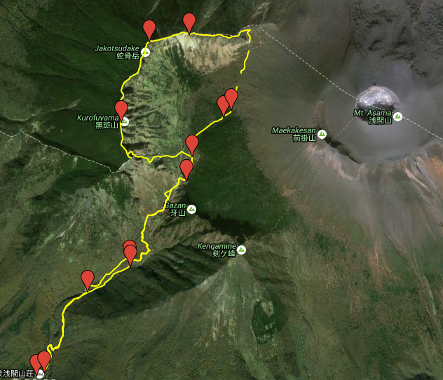
The going was super easy and quick at this point, and I reached our past turnaround point and then the junction where the trail split to go up to Asama. Sadly, I didn’t check the volcanic activity ahead of time… The alert had just been raised a week ago to level 2 and the trail up Asama was closed. So once again, Mt. Asama foiled me. Apparently, it had a small eruption earlier in the week of smoke and yesterday, a small amount of ash was deposited and caught on camera. Volcanic tremors continue to happen as well. Asama’s daily sulfur dioxide releases have been growing sharply, hitting 1,700 tons on Thursday from 500 tons on Monday. I ended up going left at the junction, following the signs for the J-Loop trail that goes along the ridgeline overlooking Asama. At this altitude, it was already much cooler and pleasant. The wind really picked up as I emerged from the treeline. Oh, it was stunning. Asama rising up on the right, windswept landscape ahead of me, and the other mountains on the left with so much green.

I ended up snacking before the steep ascent up to the ridgeline. I couldn’t believe that the trail was in front of me. It just looked like rocks! It was really fun though. I enjoy more bouldering-like hikes and the view didn’t hurt either. I had lunch at the first mountain peak, Sennindake, 2319 m. I continued crossing the ridge and hit the other two peaks, Jakotsudake, 2366 m, and Kurofuyama, 2404 m. The latter part of the trail passed in and out of the forest and hordes of gnats. I made it to the last overlook point, before descending on the other side of the ridgeline at about 2 pm. This was a rough descent as I was pretty tired and the trail was rather slippery with gravel. There were many flowers along the switchbacks down the mountain.

I made a break at the shelter to rest my aching toes, before finishing the rest of the descent. I passed by the waterfall on my way down which was bursting due to all the rain. There was even a beautiful rainbow! I got back to my car at 4:30 pm, after 8 hours of hiking including all my breaks. Not bad for 13 km with an elevation gain from 1400 m to 2400 m! I got a little headachy from the elevation change, but nothing too bad! I did have to push myself although not as much as at Oze, ha. So lucky that I had great weather too!


Wednesday, June 8, 2016


I managed to rearranged my two classes I have on Wednesdays and take the day off to hang out with Mama and Lars. I debated a lot on where to take them, but decided on Mt. Myogi since it was nearby, and I had never been to the shrine. Luckily, although the day was cloudy and wet, it hadn’t started raining yet. We set off pretty late at 10 am. It’s impossible to get Lars up early, that sleepyhead. I parked the car by the shrine, at the visitor stop and we walked over to it. I didn’t realize the whole shrine is placed on a steep hill! So many stairs! The shrine was stunning. Huge cedar trees, filled with a rainy mist. Every corner had cool parts tucked away. We spent over an hour exploring the grounds, before returning to the car. I picked up some hiking maps at the visitor center and we drove over to the art gallery and lookout park to have lunch.

We were invited in by some staff to check out the art gallery inside the building so we postponed lunch. All the art was of Mt. Myogi. Some really stunning paintings. It was definitely interesting to see, especially the little kids’ art on the third floor. We had lunch after on a bench by the empty dirt fields where cosmos grew in the fall. Afterward, I moved the car to the closest parking lot to the trailhead we wanted to take. A brief bit along the road, and we were off climbing a steep paved path that met up with the top of Mt. Myogi shrine. We split off into the woods. The trail gradually ascended with quite a few stairs. Everything was damp and green.

We climbed out to one outlook area, passed a waterfall, saw a forest crab, and a snake! Along the way, Lars shrieked several times when something got stuck to his leg. He said it was an inchworm, but later I noticed some stuck on my shoes and leggings. My legs were covered completely. They were little forest leeches with quite a bit of sucking power! They liked to hide inside your shoes too. Luckily I only got about three on me. They move really quickly! We turned around at the second outlook point. There was a chain to get to the top, but it was way slippery and not well attached. We just ended up rock climbing the small distance. The view was really pretty! I climbed over to a small outcropping. It was tricky to get there as there was really nowhere to place your feet. Lars even made it up there although he is afraid of heights. Getting back down was harder for him and required some butt sliding. He had worn the wrong shoes too.

The way back went much more quickly and we managed to complete about 4 km in almost 3 hours. We made it back in time to be able to go to the onsen. Mama managed to feel comfortable enough to try it out, and Lars was actually excited at this point. The soak was great. We left shortly after 5 pm and headed off to get dinner at the same sushi place I took Lars earlier. It was really empty this time, being a weekday, and we had to order everything verbally. Mama and I shared an expensive eel plate that got flambeed with a torch! It was delish.

Sunday, May 29, 2016

As it gets light out so early, I woke up at 4:30 am with the rising sun. Plus, it was freezing cold! The sleeping bag I had borrowed from GAJET was barely thick enough with my wool leggings. Papa had bare legs in his though! He popped out of bed quickly, got dressed before heading to the restrooms. He came back at a run though asking for my camera to take shots of the lake all misty! This was enough to convince me to get dressed as well. Pulling on all the layers helped get me moving too. After a restroom stop, where I could put my contacts back in and stop being blind, I also went to the lake shore. The mist, rising sun, water and marsh was amazing. Absolutely breathtaking. Completely reaffirmed Oze as my favorite spot in Japan. There was thick frost everywhere! That means it was a little below freezing overnight aka -1 C or so. Way off from our 9 C prediction for the night. I tried to find Papa to get my camera back, but no luck so I only have cell phone photos.

By the time I got back to the tent, Papa had already dismantled it and rolled up our sleeping bags. He was so quick! We grabbed our packs and went to eat breakfast - granola and yogurt - on some benches by the water. It was still so cold out my fingers got numb! We hit the trail shortly before seven with our packs a bit lighter with less water and food. The trail was isolated and calm. It got warm pretty quickly with the physical exercise and sun. We made it around the lake and switched from flat trails to hilly ones that headed to the great marsh. The famous white skunk cabbages were blooming in full force around the lake. We encountered more and more people, even huge tour groups. Around ten, we hit the second campground area that was surrounded by many restaurants and shops. I definitely preferred our campsite. We ate a snack here before starting the marsh boardwalks.

The scenery was quite different than from that in the fall. Much less water! The marsh was really dry with the skunk cabbages growing in sparse patches by the last bits of water. They were all past their prime bloom and wilting. We encountered more and more people as we headed towards the end. We took a break for some early lunch before pressing on to the last campground and hut site. Papa and I were exhausted and our legs no longer wanted to cooperate. We had time for a 20 minute rest before doing the last leg of our trip: upwards to Hatomachi Pass. This was really rough especially the second half as a yellow trail was pretty steep. Having a heavy pack makes all the difference. And there were so many people and tour groups that it was much less fun at this point. We did ascend pretty quickly, in under an hour.

I got us bus tickets back to Tokura, but this time the buses were all parked in a different lot! We got a bus that left 15 minutes later at 12:40 pm. After a curvy, hot ride, we got dropped off at the main bus station in Tokura. A guy helped us at the counter ask when the next bus to Oshimizu left. We had to wait 30 minutes this time because we had just missed the bus. It probably would have been cheaper and faster to use a taxi because first part cost us 780 yen and second part 540 yen. Papa wasn’t that happy we had to wait because we were on a deadline and would just barely make it in time back to Takasaki station for his 4 pm train to be able to pick up Mama and my brother, Lars, at Tokyo station! Despite barely being able to walk, we still stopped on the way back to get a quick photo with lupines, my namesake! What an exhausting, but fun weekend!

Saturday, May 28, 2016


Last night, I picked up my papa at Takasaki station! He’s working in Osaka for three weeks so he came up to spend the weekend with me! I spent Friday afternoon getting cheese and a membership at Costco, as well as grabbing burgers with S. S actually got to meet my dad as well when I dropped him off at the train station ha. This morning we left at 7:30 am to head up to Oze National Park for a bit of hiking and camping. The last leg of the drive was quite beautiful with all the flowers blooming: irises and lupines. Because the temperature is colder there, there were more types of flowers than I normally see.

We parked at the Oshimizu entrance for 500 yen a day. I had to pay a lady who emerged from the omiyage shop and tell her we were leaving tomorrow. It seemed this was a popular spot for overnighters to park. I used the Hatomachitoge Pass entrance last time so I knew nothing about this route. My dad and I both had our overnight packs with sleeping bags, food, and a tent on our backs as we started the upward sloping gravel road. I knew our first stretch to the campsite would take about 3 hours and be 7 km long. What I was surprised to find out was that about half of it was along this stupid gravel road! We were surrounded by tons of butterflies and chirping cicadas, but still! Finally we past the first hut/rest stop area and the trail actually became a wooded trail tucked along a river. So much nicer.

Sadly the trail turned into some steep switchbacks. I had to take lots of short breaks to catch my breath. The trail was lined with beautiful pink flowering trees and at one point we could drink fresh mountain water. Cold and delish! We finally made it to the top of the pass and realized we had just covered a 600 m difference in elevation from our start point! With our packs! My papa last went backpacking 30 years ago and I’ve only done it once in college, but we did it! From 1180 m to 1762 m. We stopped here for our lunch break before pressing on.

We finally made it down to the lake! It was gorgeous! There was a bit of a small pebbled beach and sandy beach. After snapping some photos, we walked the last 20 minute stretch to our campsite area. I stopped at the visitor center to get another Oze map in English plus some other pamphlets. They also told us where to go to check in. It was a little tricky with their lack of English and the lack of signage. We wandered a bit in a circle before I saw the sign Hute in katakana on one of the buildings. Managed to fill out the paper form there okay with the receptionist minimal English and told him we were only two people instead of four. It cost us 800 yen per person for our site and we got a number to hang on our tent.

There were 26 wooden platform sites in our campground. About 10 were filled. We took #2 as it was closer to the bathrooms and a bit more wooded. The toilets were pretty nice. Apparently they helicopter remove all the waste from the park to keep the water fresh. We set up the tent easily although I had left the directions at home - a standard model. After transferring water and snacks to small packs, we headed out to do some more hiking. We decided to do a smaller loop since we were both tired. After briefly passing through the marshy area, the trail branched off into isolated woods. There was no one besides us and the trail was much less maintained. Very peaceful. At the top of the pass, we emerged into a stunning marshy area with pools. The wooden boardwalk disappeared halfway through into old wobbly planks. Clearly they were doing some renovating. Nothing like practicing our balancing acts!

Once we started our steep red marked descent, we ran into a couple other people. We definitely picked the better route upwards. We emerged at the other side of the trail that runs through the campground and grabbed our pasta salad dinner. Almost all the campsites were filled at this point. We decided to have dinner while relaxing on the beach. As it was quite a bit later, many of the park’s visitors had already left. Dropping our things on the beach, we went to soak our sore, tired feet in the cold water. It was not too chilly in the shallows. But we had to watch out for glass! Broken pieces were laying on the beach from litter. We both ended up relaxing on the beach after dinner watching the sun slowly go down and the temperature drop. Papa decided to run back to the campground to get dressed more warmly since he was only in shorts and a t-shirt. I at least had my fleece jacket.

The sunset was pretty nice, but it was really restful and calm. A thicker cloud cover along the horizon made it tricky to see the sun completely set. We headed back to our tent to get ready for bed although it was barely 7 pm. We were both so exhausted! Plus it was cold out! It seems in one of the cabins, you could stop by to watch a performance with piano and hang out with the other overnight guests. I was surprised to see there were two other groups of Westerners camping too. Papa somehow managed to fit diagonally in the tent and fell asleep quickly while I read for another hour. People kept walking by so it was noisy at first, but it calmed down later. I did wake up a lot because I was uncomfortable. No side sleeping on a platform with only a sleeping bag cushion!

Saturday, April 23, 2016

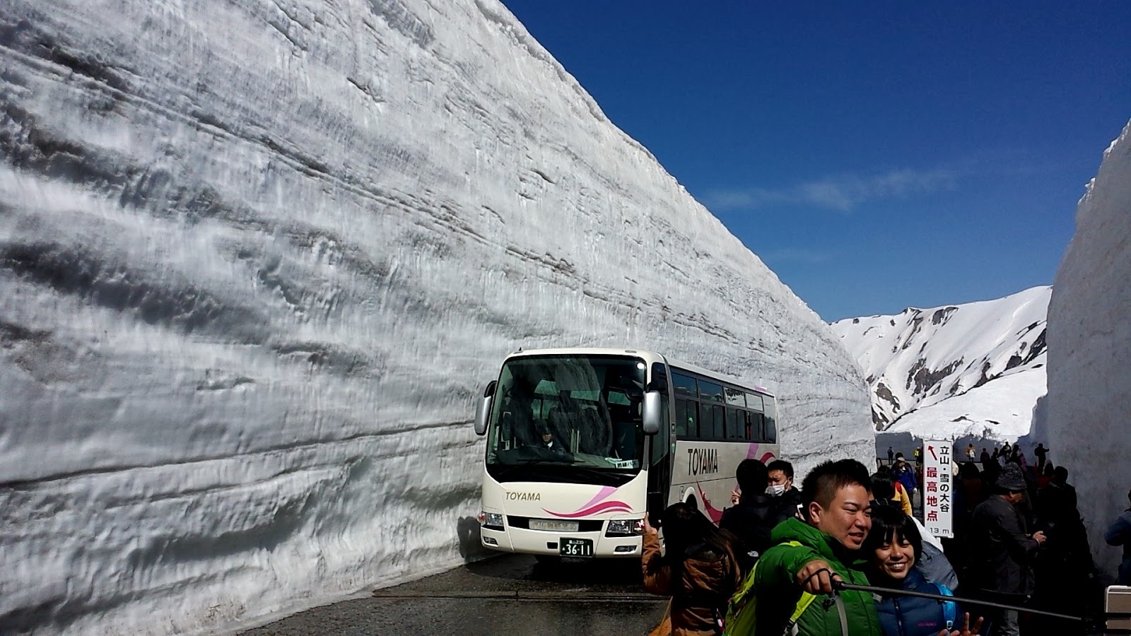
I woke with the rising sun at 5:15 am, ugh. Four hours of sleep is not enough, but it was hard to stay asleep with the car door slamming noises as well. People started lining up for tickets shortly before 6 am with the offices opening at 6:50 am for the first bus departure at 7:30 am. The Alpine Route stretches across the mountains between Nagano and Toyama. There are several different modes of transportation you take and the whole journey across can take 7 hours with waiting times. I was only going as far as Murodo where Japan’s highest altitude hotel and onsen were, and where the famous snow corridor was. Due to the lack of snow, this year it was only 13 m high instead of the usual 17-19 m. This was probably the best website I’ve encountered in Japan in terms of English information. Everything but the timetables had been translated.

I wanted to get here super early because the crowds were supposed to be intense as it was the weekend after the opening weekend. They estimated over one hour waiting lines at each station. No thank you.

It was pretty warm out already in the sun, but I wore a lot of layers anyway with my snow pants. I joined the line at about 6 am, and ate my breakfast there. I had bought food ahead of time although they sold things at a station shop (at a higher price). Many other Japanese people were waiting along with loads of skiers and snowboarders. There’s no ski resort, but plenty of places to go backcountry. It’s always impressive to me to watch people strap them on to their packs and hike with that weight. I easily got my ticket for a round trip between Ogizawa station and Murodo and took my spot in the next line for the first part of the transportation chain, riding the trolley bus.

Electric buses are rare in Japan. Unlike Czech Republic, where the inner city of Plzen was filled with them, this is the only trolleybus line in all of Japan. Plenty of Japanese tourists were eagerly taking pictures of the buses. The tunnels through the mountain took years to complete and claimed many lives. After waiting about 5 minutes, and catching the first bus at 7:30 am, we unloaded at Kurobe Dam 15 minutes later. It’s like the Hoover Dam of Japan and is the tallest one here. I climbed the many stairs to emerge from underground on the observation deck. The views were stunning. Seeing snow capped mountains is my favorite. I then descended a bazillion stairs to walk across the dam to the next station and wait in line again.

The next round of waiting took about 10-15 minutes before I managed to get on the cable car. The cable car took 5 minutes before we were at the next station, Kurobedaira. They handed us a number to tell us when we could get on the ropeway to help keep the lines down. In the meantime, I went to the deck observatory and got my photo taken at the altitude marker. The temperature was still pretty warm here although there was snow all around. After a quick 5 minute ride on the ropeway - with amazing views - I switched to another trolley bus at the next station. Again it only took about 10 minutes waiting before I could board and another 10 minute ride, before I finally arrived at my destination, Murodo!

I arrived at about 9 am at the already crowded station. It was rather confusing to find my way out towards the snow corridor. It was finally cooler at this altitude, 2450 m (8000 ft). Following the stream of people down the street, I encountered the highest part of the snow corridor, 13 meters tall this year. I got the famous bus shot with the snow towering overhead. Some years the snow is 17-19 m tall! It’s really cool to see the stratification patterns where the snow has melted and refrozen over winter. Next, I stopped by to catch a glimpse of the lake that was still completely frozen. I put on my crampons at this point because there was plenty of snow on the ground and I was slipping everywhere in my hiking boots. Interestingly enough, the top layer was kinda crusty and melted so you didn’t sink through like with the powder at Mt. Asama.

My goal was to summit Mt. Oyama, the main peak of the Tateyama range, at 3000 m. I wore too many layers and got hot quickly. It was slow going and rather steep up the first bit. You had to be careful not to slip. I made it to the mountain hut at 2700 m (a rise of 300 m from my starting point) and ate lunch. The wind was really strong at this peak so then I was thankful for all my layers! I was accompanied by some skiers, snowshoers, hikers, and snowboarders. Had a nice conversation with one guy and his group as we climbed at about the same speed. One again, they were surprised to hear that I was hiking by myself.

I started the last bit of ascent. It was extremely rocky and more like the bouldering I was used to in Maine. The patches of snow, ice, and bare rock made it tricky with the crampons. I really need the full on 6-8 point spike ones. Suddenly, the cloud cover started coming in pretty quickly and whiting out everything. Soon I could barely see in front of me. I decided to turn around at this point. It cleared a little bit, but after the partial descent I had started, I realized I was ill equipped. It was incredibly difficult going down. One of the hardest things I’ve done. My shoes didn’t grip at all and I slid a lot. I can’t imagine doing it much further than the short distance I managed. The rest of the way back was easy enough as it was just sliding down on snow for short bits. You had to watch out for hollows and cracks under the snow though.

I made it back to the hotel (the highest altitude hotel in Japan). I wanted to go to the onsen (also the highest altitude one), but mother nature had determined it was not to be. After buying some omiyage, I began the journey back. Hordes of people had flooded the route and my wait times were bad, but not awful. Most people were going in the opposite direction. I’ve never been so glad I started early. I made it back to my car and got ready to do the drive back on local roads. I ended up stopping in Ueda at a FamilyMart around 6 pm to take a nap. I was so tired from the lack of sleep last night. I could barely keep my eyes open while driving. The one hour nap rejuvenated me and I finally got home at 9 pm. What a successful, fun trip!

Side note: The next day I realized I had forgotten my glasses there! I must have left them in the restroom in the morning when I put my contacts in. I contacted the staff via the website and they got back to me saying they found them! They even wrapped them up nicely and mailed them to me by pay on delivery. Yay!

Saturday, March 12, 2016

Winter Hike of Mt. Asama

It was kinda snowing when I left the house at 6:50 am, a bit more like sleet. As I drove to Matsuida station, it changed to snow, already staying on the ground. I picked up the two guys who were accompanying me on today’s hike up Mt. Asama. They both worked for a car company and were from Poland and India. The drive to the trailhead was steep and curvy as per usual. The poor kei car drained gas so quickly. The last bit of road was rough - dirt and covered with snow, but we spotted some wild animal that ran off the road. Not sure what it was. Looked kinda like a serow but had a long skinny tail. Driving slowly, we made our way to the parking lot by the hotel/cabin/rest house where the final guy joining us was waiting. Parking cost 500 yen, but we figured we had to pay before leaving.

The trailhead was through a tori gate accompanied by a bunch of Japanese information about the current volcanic activity of Mt. Asama (浅間山), 2,568 meters (8,425 ft) tall. Mt. Asama, in Joshin'etsukogen National Park, is the most active volcano in all of Honshu with its most recent eruption in 2009. Last June, the alert level was raised to 2 and you aren’t supposed to go within 2 km of the crater. Mt. Asama is actually three volcanoes piled on top of each other. The Kurofu, the Hotokeiwa and the Maekake volcano (前掛山) which is what we were attempting to summit. The start of the trail was at about 1300 m. There was a small box to drop your hiking plans off in. We departed at about 9 am. The pristine snowy trail stretched in front of us. There was already about 4-5 inches of snow on the ground so we put on our mini-spikes and shoe grips.

The weather was all right. It had stopped snowing and was just cloudy, but the sun started peeking through. It wasn’t really windy at all nor that cold. All the physical exertion kept us hot! We got a little confused as to where the trail lead at one point since the roped off way continued straight and the rest of the trail turned around and went back the way we came. We found out that by hopping over the rope and continuing on, we weren’t on the proper trail and cut out part of the actual path. Whoops. That’s what we get for not being able to read kanji on the signs. We made it to the second shrine in about fifty minutes, completely bypassing the first shrine and waterfall with our “shortcut.”

From here on out, the snow got deeper and more and more of it ended up in my shoes. The trail wasn’t really that steep but tromping the path out through the snow took a lot of energy. We took turns leading the the front. The scenery was breathtaking. Mt. Gazan to the right and a cliffline to the left. We got to smell some sulfur as well. An older couple in their sixties passed us at this point. We were surprised to see other people! They were really sweet. I hope they enjoyed the track/trail we made. Our paced had slowed a lot due to the snow and attempts to find the trail. The little ribbon markers were very spaced out and often bleached out by the sun. So hard to spot! By the time we arrived at the volcano shelter and rest house, it was 12:30. We had our picnic lunch here and talked to the caretakers who live in this cabin. The volcano shelter part on the bottom of the house was really decrepit looking. I wouldn’t trust it to protect me! I was very happy to find an outhouse here because I was not looking forward to peeing in the snow and cold, ha. These were wonderfully clean toilets - not squat toilets! Hallelujah.

The next of the trail was very flat and through the woods. It would have been perfect to ski across or use snowshoes. We made it to the sign where the trail “ends” and you have to proceed further at your own risk. This is where we found out, we were underprepared. We had an hour left of hiking time before I thought it’d be a good idea to turn around and make sure we got off the mountain before dark. Although the trail was flat, we really needed snowshoes. Every couple of steps, you’d crash through the snow and while yanking yourself out, sunk your other leg in. My hips really started hurting and my feet were wet. The snow was deep. I fell into to my hip so it was at least 90 cm (36 inches). We pressed forward as we wanted to make it out of the trees but there was no end in sight. After the rest house, we lost service so we couldn’t check how much further we had to go either. We decided to turn around at 1:50 pm. Near the bottom, I took my spikes off as a lot of the snow had melted and I didn’t want to damage them on the rocks. I started slipping a bit more so I definitely think they made a difference even if a lot of wet snow got stuck on the bottom of my shoes!
Afterward, we could see on the gps map that we were so close to breaking through the trees. The Japanese trail map at the rest house said that it takes 2 hours to do the final climb to the peak in good weather so we definitely wouldn’t have made it to the top. Oh well, I had fun and I’d like to try it again in the summer! The descent only took us 2 hours, but this time we stayed on the official trail and got to see the waterfall that was partially frozen. We hiked a total of 10 kilometers in 7 hours. Our legs hurt badly so we stopped at the rest house to use their onsen and get a discount on parking. The onsen was only indoors, but the water was the same iron-orange that we saw while climbing. We didn’t see any animals except for chickadees, but the volcanic rocks and snow were cool!

Tuesday, November 3, 2015


Today is Culture Day in Japan so many places had free admission. I had a hike of Mt. Myogi, our nearest mountain 30 minutes away, planned. K picked me up and we began the scenic drive through farm fields heading towards the crags of Myogi-san. It has such a jagged summit line. Another winding ascent, although shorter than Akagi, and we met up with the rest of the GAJET group at Nakanodake shrine’s parking lot. About twelve of us were hiking together. As we left, the policemen gave us a map and told us to be careful. I didn’t know this at the time, but on the neighboring peak, a couple went missing this past weekend. They found the man dead, but haven’t yet found the woman.

We did a nice loop that took us about 3 hours with some waits for the chain climbs. The chains already start right at the beginning. We went passed the four stone arches of Myogi. Only one part with the chains was a bit scary coming down, but the rest had decent footholds and handholds to use. The chains were mostly an extra precaution. The views were pretty awesome and definitely make me want to do the 6-8 hour summit hike! The autumn colors were beautiful, but a bit early still. If I get a car this month, I really want to go back. I got really hot, although it was cold in the parking lot with the wind blowing. Should have worn less layers. After we came down by the shrine, some people stopped for lunch. I hung out before four of us went to the sentou (public hot baths).


I forgot to bring a little towel aka washcloth with me so I had to buy one for a little bit extra. M and I had a lovely soak especially in the outdoor bath. The air was chilly and we had a fantastic view of Tomioka, Takasaki, and Maebashi. There was a road much further, but if you walked by the edge, you were definitely flashing people, haha. We got some ice cream afterward as you are supposed to consume milk products post-bath. We all decided to get some yakimanju in Tomioka and S, who has spent a lot of time in Tomioka, told K and I about some good places! We also went to a mochi shop that had daifuku which was cold, cream filled mochi. So yummy! I got pumpkin and tiramisu flavor. Definitely will be back. It’s also right by my school. I took K and M to my bakery and picked up some things there too. Then it was finally time to head back to my house. The hike plus sentou really knocked me out and I just wanted my bed.

Thursday, October 15, 2015

How to get to Oze from Gunma

Catching bus from Numata
I did a lot of research of how to get to Oze National Park before my trip. It was rather spontaneous (less than a week before, I decided to go). Finding up to date English information was really difficult so I figured I’d summarize it here for others. This is how to get to Oze from Gunma or rather, Numata Station via public transport. Buses run from May 22nd to Oct 25th, 2015 (this year).

Getting there:
Numata Station -----> Tokura (bus) {2050 yen, 80 minutes}
[operated by Kan-Etsu]
Hatomachitoge ticket window
I found it easiest to use a site like Navitime to figure out when the bus was leaving. The exact schedule from the Kan-Etsu website was a huge pdf file with lots of tiny kanji. The bus picks you up from #1 outside the station. Lazuli Voyage has the best info in English. The first bus leaves at 7:20 am for Oze Oshimizu and stops at Tokura at 8:43 am and arrives at Oshimizu at 8:55 am {2250 yen}. Take a numbered bus ticket when you enter. At your stop, you can see how much you’ll have to pay by looking at your number on the electronic board on the front of your bus. Show the driver your number and money when getting off and put it all in a slot that faces upwards. Coins and bills.

Tokura ------> Hatomachitoge Pass (bus) {930 yen, 20 minutes}
[departs at 4:40, 6:30, 7:50, 8:55, 9:40, 10:20, 11:10 am]
My shuttle bus left at 7:40 am however to pick up more passengers on route. There are at least three different parking areas. Personally, you’ll have no problem getting up or back to Tokura. The shared taxi buses ran very often. I just bought a ticket at the window by saying my destination. If you take the bus from Numata station, it’ll drop you right at the perfect spot.

You can go directly from Numata to Oshimizu (another entrance) which I was considering. However, the last bus from Oshimizu leaves at 3:50 pm so you don’t have a lot of time to hike during a day trip. The last bus from Hatomachitoge was at 7:55 pm.

Return:
If you go from Oshimizu, you can go directly back to Numata Station (last bus: 3:50 pm, 2250 yen, 2 hours). What I did however:

Hatomachitoge ------> Tokura
[Run frequently, 930 yen, 20 minutes]
Took a shared taxi bus that left almost immediately after I boarded at around 2:15 pm because it was full. Bought a ticket from a window and followed people. The guy at the window said I had to ride back to Tokura before catching a bus to Numata so I did (had translation help here). The driver asked where to drop people off. Many people got off at the main parking lot which was a short walk over a bridge away from the bus stop so I think if you said Kan-Etsu bus or nothing at all, you’d be fine (my translator helped here again).

Tokura -----> Numata
[Last departures: 4:30, 6:30, 7:55 pm] (2250 yen, 80 minutes - took us 2 hours with traffic)
I caught the 3:12 pm bus. I asked at the ticket window and they told me the bus leaves from the spot marked #1. Some of the buses travel further than others (to Gokan and Jomo-kogen Station). My numbered ticket said 2 when I on and I got off at Numata Eki.

Easy enough, eh?

Monday, October 12, 2015


Time to talk about one of the most amazing days I have experience in my life. Nature has always been a passion of mine. I love to spend time outdoors and go hiking even though I’m not in great shape. I love to appreciate the beauty of the natural world around us.
We left J’s house at about 7:20 am in the freezing morning to drive over to Tokura where the shuttle buses run to Hatomachitoge, the park entrance. J told me that they will get snow soon up here. The morning was certainly brisk enough. Sometimes this road is not accessible for private drivers, thus the shuttle. On the way there I got to experience my first melody road! Gunma has a couple stretches of road that have striations that make a song when you drive over them. It was quite cool. We got there with perfect timing although we weren’t sure at first if we were in the right spot. J helped me get ticket at the counter and I boarded the small bus with a few others. We then drove to the next parking lot, pick up area, and filled up the rest. At 7:50 am, we were on our way up the tiny, curvy mountain road. It was a bit insane, but a gorgeous drive. Literally, pulling over, reversing and almost scraping past other buses and taxis.


I was off on my hike shortly after 8 am. K had given me her Oze National Park map in English which had some estimated hiking times. I had originally planned to go from Oshimizu to Hatomachitoge, passing by the pond and the marsh, the two most famous areas, but due my lucky ride, I switched up my plans. I considered hiking it in the other direction, but the estimated times wouldn’t have me arriving in Oshimizu before the last bus left. So spontaneous new plan: to hike a loop back to Hatomachitoge.

The trail was pretty slippery and damp on the boardwalks. I slipped a couple of times. An ambulance actually pulled up in the parking lot while I was there and during my hike a rescue staff person was carrying an older woman on his back. A river ran by part of the trail and you could catch glimpses of a mountain. The colors were just absolutely stunning. I made it out of the woods to the first rest area where they had a campsite, lodges, and food. The boardwalks through the Ozegahara Marsh began here, one of the most iconic parts. Breathtaking. I couldn’t stop taking pictures. There were certainly a lot of people around. I even saw a guy with packages strapped on his back really high. He was delivering them further into the park to some of the other lodges and food areas (even the ones on the mountain summits). Crazy!

I split off from the marshland back to a mountain to take the trail back. I didn’t read the map well enough so I’d underestimated what I’d gotten myself into: climbing up a mountain pass, summiting, and heading back down. It went up about 500m in under a kilometer. It was quite difficult, but looked even worse for the people heading down towards the marsh! There were much less people on this trail so it was quite peacefully especially since many Japanese carry bells on their hiking packs to avoid the bears. I think? They also carry an insane amount of stuff with them for day hikes. People whipped out their bento boxes with camping burners, made tea, coffee, cooked dumplings. It was crazy. Everyone here also really dresses the part of a hiker. All fully equipped with the right shoes and clothing. It’s very interesting to see the hordes of us on the trains afterward.

I ended up hiking at the same pace with this Japanese guy and he struck up a convo with his few words of English and my few words of Japanese. He was a sports teacher in Saitama. We kept each other company up to the top where the next break house was. He was also heading towards Hatomachitoge, but we split here since he was going to wait on his friend. I kept going towards the summit of Mt. Nakamura! It was astonishingly beautiful up here. Left me speechless. I ended up taking a break here and he caught back up to me with his friend. His friend worked in a hotel in Tokyo so he could speak a good chunk of English. We hiked the whole descent together and made a bit of conversation. This is exactly why hiking alone can be fun! They even stopped and made me coffee towards the end. Although he accidently used aloe water which led to an interestingly flavored, not-so-drinkable coffee. After we finally made it back down, they bought me coffee from a vending machine instead. So kind. We took some pictures together by the trailhead. We all bought tickets back to Tokura and they helped ask for me about the bus to Numata. The guy told us that I’d have to catch it Tokura. We just boarded a taxi shuttle that left almost immediately. The driver wanted to know where to drop people off, so they helped me out here again with translating.

After the harrowing drive back down, we dropped one pair by the ski slopes parking lot and the rest at the main parking lot. It was a short walk back to the bus stop. I asked at the ticket window aka said my destination, and they told me the first one in Japanese. I waited for about 10 minutes at the stop labeled with a 1, and boarded the bus for Numata. We hit some crazy standstill traffic on the way down, but at least it was an interesting drive past so many orchards. I wish I had had more time to get some apples! I got off at the right stop, and caught my trains back home. Whew! My legs will hurt tomorrow.

In total, I hiked a little over 6 hours with breaks for a total of 17 km aka 10.5 miles. I was a bit quicker than the estimated hike times on the map. I want to definitely go again in the spring!